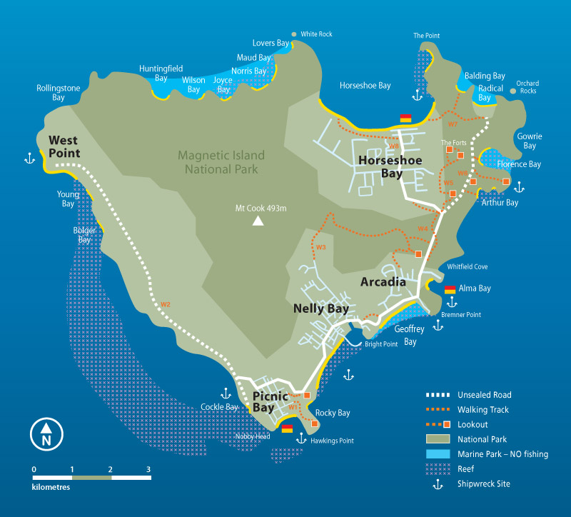
 Magnetic Island – sits only 7.km (4NM) north of Townsville and offers both shore and boat dive. It is serviced by both passenger and vehicle ferries which leave regularly from Townsville. A Snorkel Trail has been setup on Magnetic Island which can also be used as a starting place for first time divers on the Island, for the more adventurous there is also a Shipwreck Trail however not all of those are underwater.
There are many different places to dive on Magnetic Island, here are some suggestions with advice on how to dive them from local club members.
SS Moltke – Geoffrey Bay
Platypus Dredge
Picnic Bay Jetty
Orchard Rocks
Coconut Reef, Rocky Bay
Balding Bay
Alma Bay
Bremner Point
Arthur and Florence Bays
SS Moltke – Geoffrey Bay
Find the large blue buoy (GBR public use 2-hour limit) amongst the yellow snorkel trail surface floats. If entering from shore, the blue buoy is most visible from the turn-around section of the old vehicle ferry landing. Descend from the blue buoy using its mooring line as a guide, because, as with many dive sites around Magnetic Island – visibility can be a challenge so it’s easy to move off the wreck site without being aware of it. From the base of the mooring, locate the experiment platform; recognisable by its various metal arms supporting sampling instruments. Shoot a compass bearing of 60 degrees (being mindful of the proximity of your compass to the metallic platform). Swim on 60 degrees for around 15m until you find a large cylinder lying over the coral with the shape and size of a ship’s mast. This marks your start point, so from here you can swim the wreck in circuits, with the deepest section no more than around 6m, depending on the tide. The trick to diving this site is slowly! There are resident schools of sweetlips (of several varieties), bat fish, yellow-tail fusilier, and Moses perch, many juvenile coral trout, drummer, rabbit fish, and the occasional flowery cod who are all quite used to the mechanical sounds and bubbles from divers, but if you approach them very slowly, they will not scatter, instead allowing you to swim right in amongst their numbers. Look under parts of the hull where it disappears into the sand and you’ll often find painted crayfish. Also spend some time exploring the surrounding coral heads and bombies, because Geoffrey Bay seems to attract white and cream, plus black and purple nudibranchs, and you can usually find anemones without much effort.
Platypus Dredge
Townsville’s first dredge boat, employed to deepen the shipping channel, can now be found hard up against the shoreline of the first small rocky cove past Arthur Bay in about 3m to 7m of water. When you approach by boat, look up behind the cove to the small hill and find its lowest point. From here, follow the outline of a rock fall down to the water’s edge, where it finishes at a very large flat rock. This rock will be obvious, because from this distance it looks as if it has been deliberately cut into a table-top flat shape. Enter the water in front of this large flat rock and swim along the shoreline back towards Alma Bay. You will find the wreck remains covered over by hard coral, with the most recognisable features being square boilers and their associated steam plumbing.
Picnic Bay Jetty
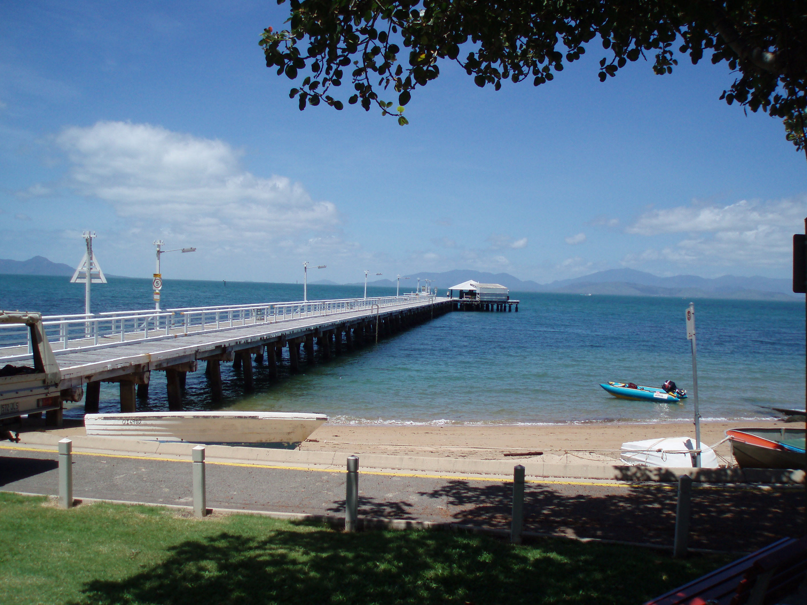 In the right conditions, the Queensland Heritage listed Picnic Bay Jetty can be a very interesting dive, even though it falls into the category of ‘muck-diving’. Many people are familiar with its recent history and the role it played in the Townsville to Magnetic Island tourism scene as a passenger ferry landing (until its replacement by the Nelly Bay terminal), but its underwater scenery hasn’t been explored widely by divers.
Maximum depth at the head of the jetty is around 6m, and the best visibility we have experienced here is 5m. The ideal breeze is from the north as Picnic Bay can be affected by southerly winds.
There are two methods for a buddy pair or small group to dive the jetty, either shore based or by boat:
If shore based, we recommend entering the water right next to the start of the pylons at the beach, because the passenger loading steps at the head of the jetty have now been removed, and even at full tide the jetty is too high for a giant stride entry. Before you gear up, it’s a good idea to walk the jetty to gauge how many people are fishing, and to identify clear areas and also spots to avoid. Swim out on the surface so your presence in the water is obvious, and so you can accurately descend at the point you have previously selected. As a general rule, if you remain within the boundary of the outer pylons then you will avoid fishing lines.
If diving by boat, have your skipper drop you just short of the jetty, and approach it at ![]() the surface whilst looking for a clear area to descend. The skipper can then move back out beyond the no-anchoring boundary, or move into the beach on the western side of the jetty. Either way, you will be able to signal them to collect you after your dive. The no-anchoring boundary in Picnic Bay is a line drawn from the head of the jetty to the southern-most tip of Hawkings Point.
the surface whilst looking for a clear area to descend. The skipper can then move back out beyond the no-anchoring boundary, or move into the beach on the western side of the jetty. Either way, you will be able to signal them to collect you after your dive. The no-anchoring boundary in Picnic Bay is a line drawn from the head of the jetty to the southern-most tip of Hawkings Point.
It is possible to reach the head of the jetty swimming on a compass bearing from outside the no-anchor boundary, but without first knowing which areas to avoid; you run the risk of clashing with fishermen. For example, in 2007 NQUEC conducted a series of clean-up dives under the jetty as a well-publicised Clean–Up-Australia Day activity, and a fisherman hooked a pelagic fish at the head of the jetty right as I was attempting to pass up a full bag of collected rubbish. The fisherman and the fish battled it out under the watch of a growing crowd for about five minutes until one final commotion at the surface which left the dejected fisherman reeling in only the severed head of the fish. I was working in the water only meters from the attack, but what surprised me the most was the fisherman discarding the fish head back into the water right next to me!
Whether you dive the jetty from shore or by boat, you will definitely be sharing it with other people, so good common-sense diving practices are needed. Regardless of the time of year, a full length wetsuit, booties, and gloves are a must because there is a real potential to cut bare skin on parts of the structure. A knife is highly recommended because we’ve found the remains of cast nets stuck to pylons. Each diver needs a torch as you obviously lose natural light under the jetty, but in addition to the torch; we’ve found that attaching a glow-stick to each diver’s tank valve helps to keep buddy pairs together. Your buoyancy control on this dive is also important, and a good way to achieve it is by slowing everything down, even in good visibility. If you take your time, you’ll stay together, and also give yourself the best possible chance of seeing the fish life.
The jetty is somewhat of a fish attracting device, and you can expect to see large schools of small diamond fish, pike, and sardines. There are also resident schools of sladey bream, plus lion fish, toad fish, juvenile coral trout, lagoon rays, and wobbegong sharks. We have also seen stone fish on every dive here, some as large as an AFL football, so careful placement of hands and feet is required. Also take your time to study the outer pylons, as these have become micro-communities housing soft corals, sponges, sea urchins, nudibranchs, cleaner shrimp, and mussels.
One final recommendation; when the jetty was  refurbished in late 2010, early 2011, and then after TC Yasi, many of the old metal straps which joined posts to beams were discarded in-situ. In some areas around the perimeter of the jetty, these metal straps now sit on the bottom meshed together, so you need to be careful when finning over and around them.
Orchard Rocks
 Orchard Rocks are located about 200m off the Magnetic Island shoreline in between Radical and Gowrie Bays. This site is fairly exposed in a typical south easterly breeze, but it is one of the few Magnetic Island locations where you can dive deeper than 10 meters. Depth at the base of the rocks varies from around 13m on the inside to 15m on the outside.
Orchard Rocks can be a challenging dive in low visibility and high current, so whenever you approach this site, always have an alternate dive in mind just in-case conditions are unsuitable. For example, the western edge of Balding Bay has a great little wall in about 7m. Another factor to consider here is that on a calm day you will likely be sharing the rocks with fishermen. In this case, you may have to limit the ground you cover to avoid getting close to other vessels, for example; by limiting your exploration of the rock to only it’s inside face.
Ideal conditions for Orchard Rocks are an early morning high tide with a slight southerly breeze, as you will get slack water on the top of the tide plus protection from the island. Once your skipper/surface-watch is happy with the boat position, use your anchor as a descent line and check that it is firmly secured before commencing your swim. Just before descending, it’s a good idea to shoot a compass bearing to the rock, just to give you an idea of where the rock is in relation to your anchor if you end up spending some time adjusting the anchor and lose your feel for where the rock is in relation to it.
When the visibility is greater than 4m, we recommend swimming around the base of the rocks at 10m, this way you can view both the bottom and the base of the rocks without much effort. There is some excellent structure around the base, especially on the northern side where stacked-up boulders have created swim-throughs. This slightly deeper outside face also seems to be preferred by fish, where ledges and cracks give protection to cod, trout, and sweetlips. You can also expect to find angel fish, bat fish, drummer, plus all the usual fusilier and small wrasse species. We also noted feathered sea stars plus white and cream nudibranchs in large numbers around the base of the rocks.
One final recommendation: Take note of the distance you swim over the bottom from the anchor to the base of the rocks and mark this point. We have found a glow stick or an inflated surface marker buoy tied to a string on a 3 pound dive weight works well for this purpose, because it gives you a reference for where you started your dive. From this point, swimming the distance you came over to the rocks but on a back bearing should get you close to your anchor, and the anchor rope will provide a safe and easy ascent.
Coconut Reef, Rocky Bay:
Coconut Reef is a fairly narrow strip of fringing reef about 100m off-shore in Nelly Bay. It starts near the southern end of Nelly Bay (referred to by locals as Rocky Bay) and finishes just before the new mariner and ferry terminal. Many divers access this reef near the accommodation complex; Base Backpackers. At this southern end of Nelly Bay, there are areas to park your car and gear-up in shade just off Nelly Bay Road, but be wary of green ants nesting in the trees just above the beach as they seem to coordinate their attack when you’re getting into your wetsuit!
This end of Coconut Reef also has a Snorkel Trail
From the early to mid-naughties, the accommodation complex contained a dive shop called Ocean Dive. Their staff mapped sections of Coconut Reef, and by using a compass combined with their directions, you could find noteworthy points without much effort. I recorded one of these map-guided dives in a log book entry: Enter the water from the old boat ramp in front of the accommodation and swim east for 50m until you hit the reef. Turn south and swim along the reef edge until you find a sand gully separating two patches of reef. Follow the sand gulley all the way out behind the reef until you find a cluster of several large coral bombies. From here, swim north along the outer edge of the reef before returning on a south westerly bearing.
These old logbook directions are included only to show how this site had been explored, but a feature that has kept me returning is the large patches of lettuce coral. This light green coloured fragile hard coral houses lots of interesting little critters like nudibranchs, wart slugs, scorpion fish, and cleaner shrimp. In recent years however, the growing space of the lettuce coral has been reduced by large blooms of seaweed. One variety called Sargassum has taken over some sections of the reef, although it does appear to be seasonal, dropping away over cooler winter months. Sargassum is also the subject of research and control projects;
Reef Recovery at Magnetic Island
A note on navigation: Water depth over Coconut Reef is around 7m to 8m so you can cover a lot of ground in one longer dive comfortably. If you spend time over a big patch of lettuce coral it can be easy to lose your sense of reference to your start point, but you can remain reasonably aware of it by swimming on repetitive 90 degree compass bearings, i.e. a box. I don’t recommend counting fin strokes (because I’m also concentrating on looking for fish life and features), I simply try and maintain a consistent speed and make turns according to my dive timer, so that I’ve at least swam for the same period of time over each section of the box.
Mooring options: If you visit this site by boat, there used to be a white 240mm mooring buoy in front of Base Packers, just south of where the beach finishes. To my knowledge, this buoy never had any markings, and it is unclear who owned or maintained it, but we assumed it was associated with the accommodation back when it operated a dive shop. The 180mm yellow surface floats for the snorkel trail are designated as no-mooring, so if you don’t find a suitable mooring, we recommend moving back to the outer edge of the reef and anchoring over sand.
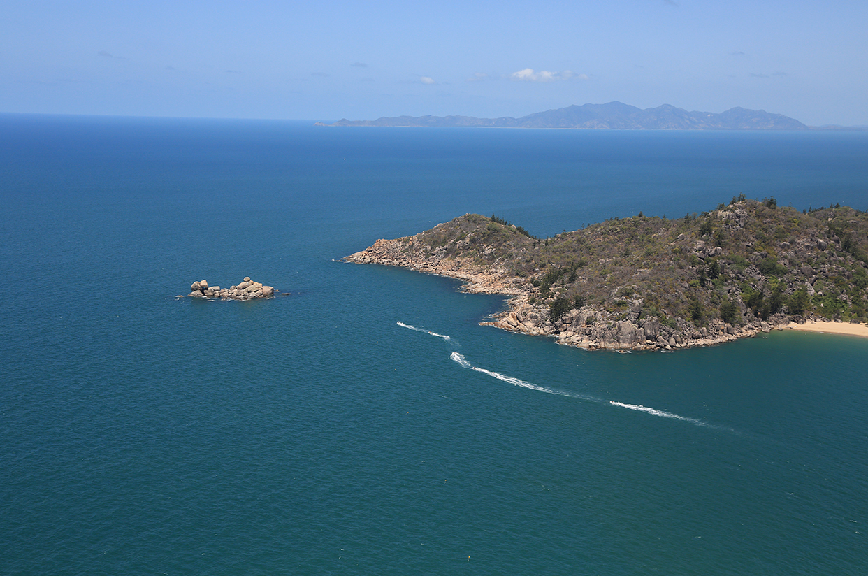
Balding Bay
As mentioned previously, Balding Bay makes a good alternate dive site if conditions around Orchard Rocks are rough, or if the rocks are being used by a large number of fishermen. Aim to position your boat right in the middle of the bay, far enough inside each point so as to get calm water. On a clear sunny day, this bay receives plenty of visitors from Horseshoe Bay, so don’t forget a towable dive flag. There is a nice wall in about 7m of water running along the western shoreline of the bay which starts where large boulders have created a sharp 90 degree point (directly opposite the Balding Bay name in the attached Google map). Visibility in this section of the bay can reach 7m to 8m in ideal conditions, and we have not yet experienced any significant current or swell at this site, (in this case the term ‘swell’ is used to describe the ‘washing-machine‘ effect you sometimes get when diving shallow walls near open water).
You can expect to find juvenile painted crayfish along this wall in cracks and over-hangs, plus mid-sized coral trout; although in recent dives here we have noticed table quality fish tend to be a bit skittish around divers. Another interesting aspect of diving Balding Bay is the unusual finds that can be made here, in terms of little on-water mishaps. We’ve found all sorts of boating and fishing equipment on the bottom at this site, such as; stainless steel ladders, telescopic gaffs, fishing rods and reels, dive weight belts, anchors, and mooring buoy hooks.
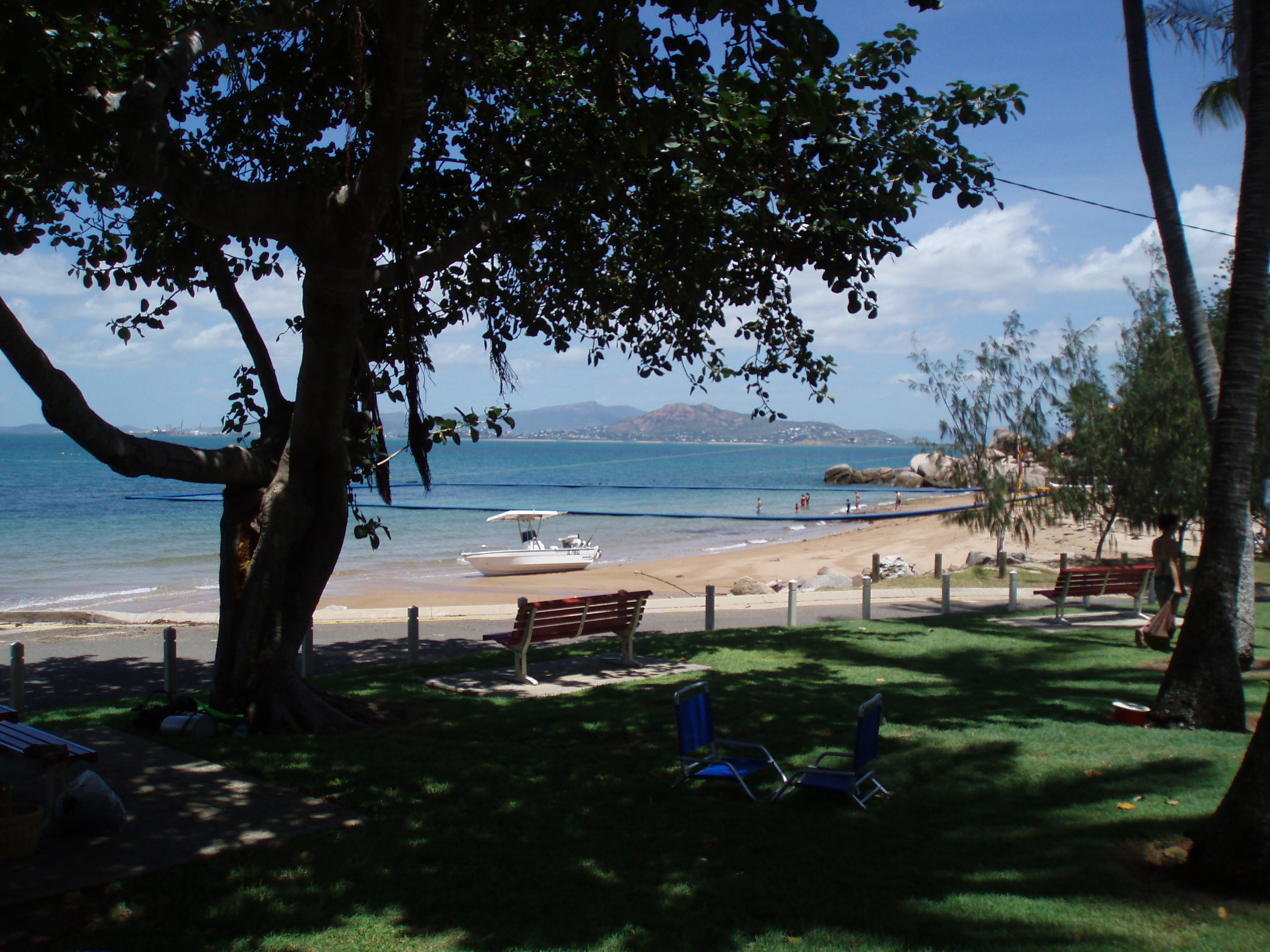
Alma Bay
The iconic Alma Bay is a QLD Surf Life Saving patrolled beach just north of the Arcadia village. The bay has a rocky headland above each end of the beach, which deepens along a gentle gradient to about 5m to 6m at the mouth of the bay. Because of the site’s protection, Alma Bay is used heavily by local operators to teach people to dive. Divers also come here to test new gear and practice their skills, such as compass work and search techniques. I tested my first pony bottle in this bay by timing how long its air volume gave me at 5m, and I’ve trialled different designs for home-made towable dive flags.
Alma Bay also makes an interesting ‘treasure-hunt’ dive due to the high volume of students. We’ve found all sorts of equipment here including sun glasses, masks, snorkels, individual dive weights, full weight belts, dive knives, and underwater slates.
A good way to dive Alma Bay is to swim out along one shoreline, move across the mouth of the bay on a compass bearing, and return along the opposite shoreline. For example, if you start out along the southern shoreline, you’ll swim past the remains of an old jetty in about 1.5m of water. The jetty attracts small fish life and we have often seen lagoon rays and port jackson sharks partially hidden in the sand under the structure. As you move along, the shoreline turns into a small rock wall and you will likely see small coral trout, angel fish, unicorn fish, honey-comb cod, squirrel fish (under structure), sweetlips, and schools of fusilier and diamond fish.
After swimming about 200m beyond the old jetty, a near-north (340 to 360 degree) bearing will get you across the mouth of the bay to the northern shoreline. There is a patch of reef in the centre of the bay made up of low-lying rock and coral rubble, and although the bottom here looks quite featureless, we have spotted Christmas tree worms, nudibranchs, and small painted crayfish hiding in holes and cracks.
The bottom closer to the northern point changes markedly from the mouth of the bay, with large boulders creating small caves and swim-throughs. The water off the eastern end of the point deepens to about 8m to 9m, and we’ve found very pretty fish around the boulders here such as six-banded angel fish, banner fish, and moorish idols. Some caution is needed around the point in a south easterly breeze though, because if you come in too close it can be difficult to retrace your path back out and away from these oyster-covered rocks in stirred up water and a choppy swell.
You can either return along the northern shoreline, or move back into the bay and head into the beach over sand. If you chose the latter, pay attention to the bottom, as we’ve found some very strange critters in close such as large snail shells (15cm to 20cm long) and cowrie shells, and I have bumped into big turtles close to the beach.
Bremner Point
Bremner Point separates Alma Bay from Geoffrey Bay, and is also referred to as the Geoffrey Bay Headland. The following site profile is based upon a series of shore dives made from the old vehicle ferry landing/departure point. During these dives, we swam around Bremner Point towards Alma Bay, progressively covering more and more ground with each dive as we became more familiar with the site.
If you have a car on the island, you can park at the end of Armand Way and gear up under the old ferry passenger hut, now used as a rock wallaby feeding and viewing platform. You can either enter the water from the disused vehicle ferry ramp, or walk out along the old track, under the rock which features in postcards and tourist brochures, and enter from a large flat rock which was once used as a footing for a jetty. If you enter from the ferry ramp, the bottom is just featureless coral rubble and sand because of the dredging effect from the ferry’s engines, but just off the car park it’s worth keeping an eye on the surface as there is a resident school of diamond scale sea mullet that hangs around hoping for a feed from tourists.
Not far past the carpark, the shoreline begins to deepen and forms a shallow wall in about 7m to 8m of water. Work your way slowly along this section towards the southern tip of the headland. We found this first section of the headland often holds more small fish life than the wreck of the Moltke. For example, we found juvenile red emperor, bi-coloured angel fish, bat fish, beaked butterfly fish, grassy sweetlips, banner fish, plus big schools of yellow-tail fusilier and Moses perch. The structure here is also quite interesting, with detached coral heads, tiny caves, and over-hangs. Parts of the headland must also be subject to current because we found fan corals anchored to the wall and pointing out towards Cleveland Bay with filter-feeding animals in their branches, plus plenty of red and white sea-whip corals.
At this site, it’s easy to lose track of how much distance you have covered, so it’s a good idea to have a designated turn-around cylinder pressure, such as 120 Bar. A torch is useful too, especially for exploring small caves and ledges. Bremner Point is also highly suited to ‘follow-along’ diving, where your skipper/surface watch keeps track of your progress by following your bubbles along, and can pick you up whenever you decided to end the dive.
Arthur and Florence Bays
Any dive or snorkel literature on Magnetic Island would be incomplete without including Arthur and Florence Bays. These two sites are among the most highly photographed and brochure-featured locations on the island. Their picturesque scenery often sees them used for weddings and other special events such as end of year functions and school excursions. Both bays are serviced by Radical Bay Road, which begins at the Horseshoe Bay bus stop near the start of the Forts walking track.
Unfortunately, Radical Bay Road seems to be in a constant state of poor repair, but a vehicle with decent ground clearance will get you to Arthur Bay first, then Florence bay, and eventually all the way out to Radical Bay. There are some deep wash-outs on inclined sections where rain can generate some momentum, and passing vehicles can be a challenge as Kapok trees grow right up to the road verge. For this reason, our preferred way to dive these two sites is by boat.
Hard corals such as brain, staghorn, and lettuce seem to have established most successfully in the northern section of each bay, although we’ve found that to find nice patches of fringing reef you need to be prepared to drop in at several locations and move your boat in between exploratory dives. For example, in Florence Bay inside the no-anchoring area about 50m off-shore lies a patch of healthy lettuce coral running parallel to the northern shore line in around 7m of water, yet the bottom either side of this patch is devoid of coral. Both bays also seem to be affected by sargassum blooms in hotter periods, so plan your visit here during winter when macro-algae die off. Both bays have good snorkelling in the shallower sections off the northern end of each beach, and on calm days these corners become packed with snorkellers and swimmers.