Pelorus and Orpheus Islands
 Introduction: These two islands are the northern-most islands of the Palm Group within the Halifax Bay region. They are separated by a channel approximately 800m across. Combined, they provide many kilometres of shoreline and fringing reef, which offers hundreds of potential dive sites. The following site profiles were assembled from both shore-based and boat dives, and are grouped under; Pelorus, Channel, and Orpheus. NQUEC names are used for the Pelorus and Channel dive sites, and common map names are used for the Orpheus dive sites.
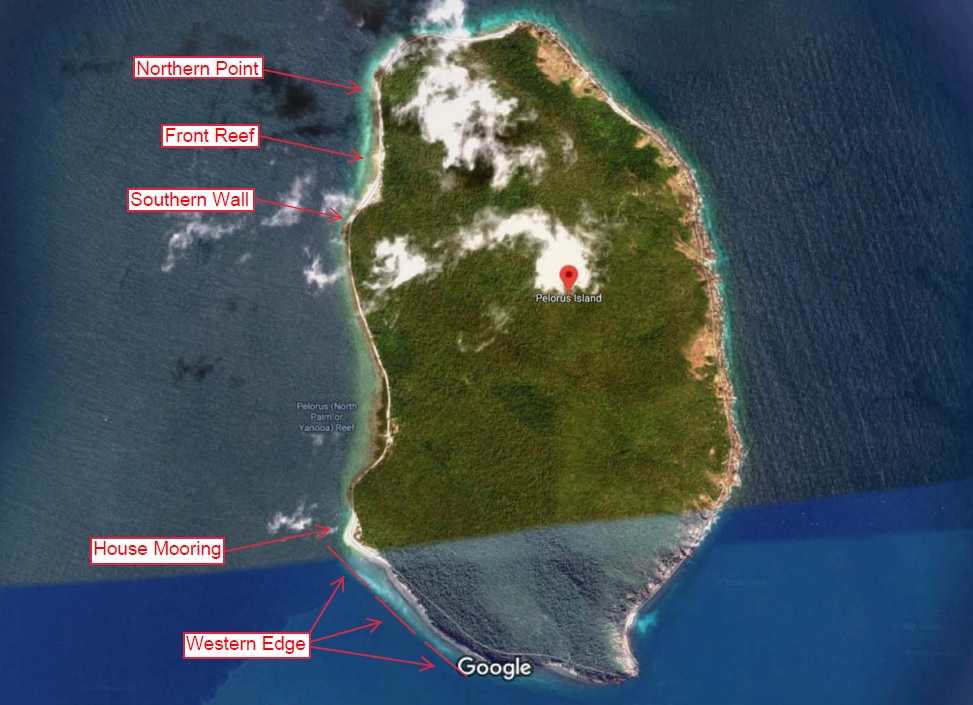 Pelorus Island (or North Palm) is a relatively small island at 2.9 km long by 1.7 km wide, and lies approximately 16 km east of Lucinda. The island is surrounded by Habitat Protected inshore fringing reef (dark blue zone), and the land is managed by the local Hinchinbrook Shire Council. Wilderness camping (meaning campers must be fully self-sufficient) is permitted on the island without a booking (current as at late 2018).
Front Reef: This site is named in relation to where the club usually establishes a group campsite, i.e. it’s immediately to our front. Behind the island’s north-western beach, a creek runs down from the ridge line to a point about 250m above the southern end of the beach. I recommend entering the water in front of this creek as the inter-tidal zone here holds less coral rubble, which makes walking with your gear and donning your fins a little easier. I personally define the boundary for this site as being 200m north and 100m south of where this creek terminates behind the beach. Once you move out beyond the coral rubble you will find a gentle 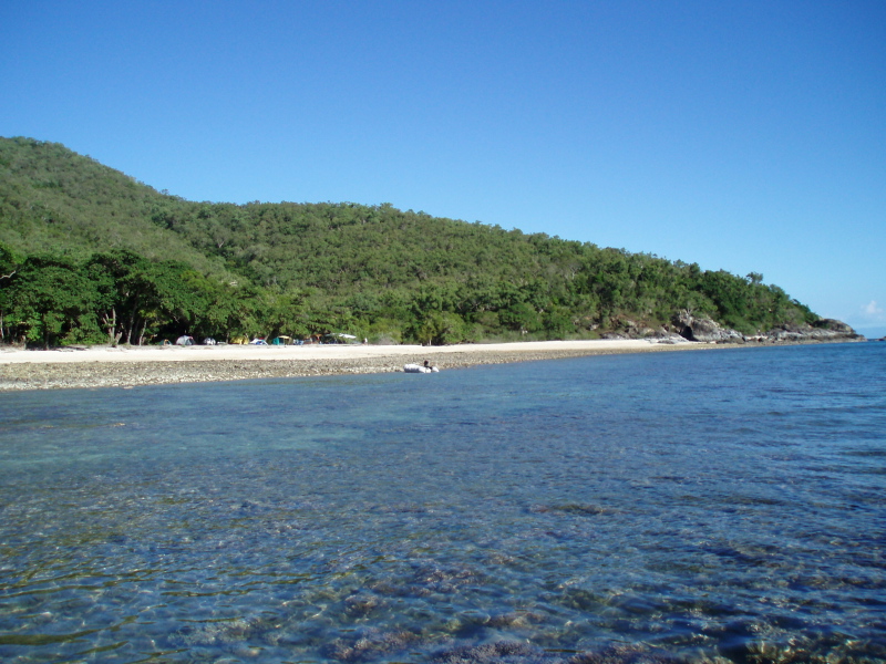 reef slope and a nice little wall between 6m and 10m, broken up in places by sand patches and colonies of low-lying staghorn coral. On a high tide, small reef sharks and even juvenile manta rays hunt around in the shallows, and in winter months keep an eye out for humpback whales traversing the Palm Island Passage. This site also makes an excellent night dive, and as long as you stay reasonably close and shallow; the glow from a beach campfire provides a useful navigation aid, plus a reminder of what good things await if you are feeling cold and wet!
Northern Point: This site extends from ‘Front Reef’ up to and just beyond the end of the beach. It follows the same shallow reef wall, although it is referred to as a separate site because of how different the terrain becomes as you approach the point. Depth at the point increases to around 15m and the wall becomes less recognisable, with detached rocks and coral bommies jutting out down towards deeper water. This area has some small swim-throughs between bommies, and you can almost always find barramundi-cod and sweetlips under ledges around these structures. This site also holds large coral trees which seem to act as ‘mini-habitats’, sometimes containing juvenile bat fish and lion fish, tiny glass fish, plus mussels and other filter-feeders.
Note: The outgoing tide at this site can produce a hefty current running in a northerly direction.
Riding the Pelorus Island Express
Concentrations of gorgonian fans with the same orientation often indicates an area’s dominant tidal flow. This is particularly evident at the Pelorus Island site we refer to as ‘Northern Point’. On a Pelorus trip over the Easter holiday period, one of our divers described the current running along the inside of the island as the ‘PIE’ (Pelorus Island Express). If you’ve experienced the full strength of this current then you will appreciate just how apt the description is, because it can make you feel like a passenger on a ride!
In recent years, NQUEC has conducted several dives on and around ‘Northern Point’, with varying degrees of success. If not timed to strictly coincide with slack water, then diving here can be challenging, and on a few occasions we’ve even aborted dives because of the current. For this reason, my own interest in this site had waned, until we discovered that when you hit the mark here with tide timings, you can be rewarded with some of the best in-shore fringing reef diving in the region.
On this trip, we tried diving ‘Northern Point’ at the top of the tide, and on one of our initial dives; we descended right on the high tide time (as gazetted by the BOM for Lucinda off-shore). This seemed to give us a 30 minute window of calm water. However, at about 35 minutes of dive time the ebb tide began to produce a slight northerly current. At 40 minutes we needed strong fin strokes to make headway, and by 45 minutes we exited the water as the ‘PIE’ began ripping along the beach.
Based on this experience, we recommend timing your dive so you are on the site 15 or 20 minutes before the peak of the tide. This should give you plenty of time to explore the area and exit the water before the ‘PIE’ reaches full speed!
If you are camping above the island’s north-western beach; you have several ways to get close to ‘Northern Point’. A beach walk is possible, right up to where the sand gives way to stones, although water entry here over the rocks is difficult. A surface swim is also feasible, and you can spend your transit time snorkelling over the coral gardens. Another option is to wade north over the intertidal rocks in water deep enough to support the weight of your gear. We found this last option the best, because it requires minimal energy, and on the high tide you will be treading on stones, not corals.
If you are diving the site by boat; consider heading south into the northerly current, and then returning to the vessel with the aid of the current. On a calm day, you could also run a live vessel by following the group’s bubble trail. Both methods require a dedicated surface attendant, and if you elect to anchor up, a mermaid line is highly recommended.
Southern Wall: This site name describes the shallow reef wall which starts approximately 100m south of where the creek terminates behind the beach. As you move south away from ‘Front Reef’, the coral rubble gives way to shallow coral gardens. At about 5m you will find sandy patches sloping away gently to deeper water, and then a uniquely-shaped coral bommie at around 7m. This bommie looks very much like a ‘corner’, and sometimes becomes a focal point for two opposing currents. It marks the start of ‘Southern Wall’, which runs all the way south into the next bay at a depth of between 10m to 16m. A good way to dive ‘Southern Wall’ is to head south along the base of the wall until you reach your group’s pre-determined turn-around tank pressure, and then return in shallow water at the top of the wall. As you move along the wall, also keep an eye out to deeper water, as large pelagic fish such as trevally and mackerel often patrol this area.
‘Southern Wall’ is heavily populated by sea fans (gorgonians) and barrel sponges, and it also seems to be favoured by reef scientists; as you will often see experiments in among the corals. Take your time on this dive, as we’ve made some interesting small-critter finds here such as; slipper lobster, octopus, eels, and intricate nudibranchs. Also look out for an impressive 6 foot tall black coral tree at the base of the wall in about 12m.
House Mooring: A house is located on the south-western tip of Pelorus Island above a beautiful little sandy beach, with a mooring just off-shore in about 10m of water. The first time I visited this site, I intended to complete a large circuit dive in front of the house, but we found the shallow reef wall so good, we just kept following it all the way into the channel. A small colony of giant clams can be found in shallow water close to the house, and the area also seems to suit smaller marine life such as; Christmas tree worms, feather stars, nudibranchs, painted crayfish, and cleaner shrimp. We’ve seen pelagic fish here too, although the site does receive some fishing attention, with lost tackle being a fairly common site. I also recommend staying clear of the mangrove-lined shore to the north of the house, as the coral cover here becomes fairly sparse.
Note: Before attempting to use the mooring buoy here, we recommend checking its conditions of use, as it may now be a private mooring for use only by the holder of the house lease.
Channel Diving: Prevailing south-easterly breezes and strong currents can make diving here challenging, but if you are patient and plan your dives at slack-water, then you can be rewarded with excellent visibility and some great structure. The approximate mid-point of the channel is a GBRMPA zone boundary, with the Pelorus side being Habitat Protected and the Orpheus side being Marine National Park.
Western Edge: This site begins off the house point and continues along the southern face of Pelorus Island, which also becomes the western edge of the channel (looking out to sea). During winter dives here, we’ve sometimes enjoyed 15m visibility, and even to a back-ground of whale-song! You can dive here from an anchored vessel, or a ‘live’ boat with your skipper following along. Either way, you can cover a large amount of terrain as the reef wall off this section of Pelorus rarely exceeds 14m in depth. The base of the wall houses some very large brain corals, with under-cut sections big enough to be used as swim-throughs. This area also supports many sea fans, possibly due to the channel’s ‘bottle-neck’ effect on tidal flows.
Ray’s Lump: In the mid 2000’s, a group of club members conducted a series of exploratory channel dives from private vessels, choosing their locations according to how the structure looked on fish-finder displays. They found a small pair of closely spaced coral ‘out-crops’ in an area of otherwise featureless terrain, and named the site paying credit to the diver who discovered it. Each coral out-crop is a miniature reef about the size of a tennis court, which rise a few meters above the surrounding sandy bottom in around 16m of water. Both out-crops are elongated, with their longest centre lines orientated in line with the channel.
I was introduced to ‘Ray’s Lump’ in 2007, and I was very impressed by it. My last dives just before ‘Ray’s Lump’ were in PNG, and I made a dive log book entry at the time describing it as being “on par with some of the small reefs near Madang.” This small site is packed full of life, with clouds of fusiliers above each out-crop, and trout, sweetlips, and cod living in and around the hard coral structures. It also appears to have resident blacktip reef sharks which circle the site over the sand.
Note: Even though we’ve omitted the exact location of ‘Ray’s Lump’, we wanted to at-least include an overview for the site; to both promote the channel area and to encourage divers to explore it.
Danger Marks: This site name is a reference to the isolated danger marks which signal the position of shallow water along the Orpheus side of the channel. As you approach the first of these marks, (from the inside of the channel heading out to open water) look out for a large up-right boulder on the Orpheus shoreline which dwarfs the nearby rocks. Move towards the first mark until this boulder is directly over your right shoulder, and then head out away from shore into the channel until you find at-least 5m of depth. A good way to dive here is to swim a large ‘box’ making repetitive 90 degree compass turns.
This is a shallow dive site, but it has some quite interesting terrain. For example, there are gutters in the rock base with walls which have an unusually high degree of accuracy and symmetry. These gutters contain colourful low-lying corals, and also seem to attract juvenile reef fish such as red emperor, coral trout, wrasse, parrot fish, and sweetlips.
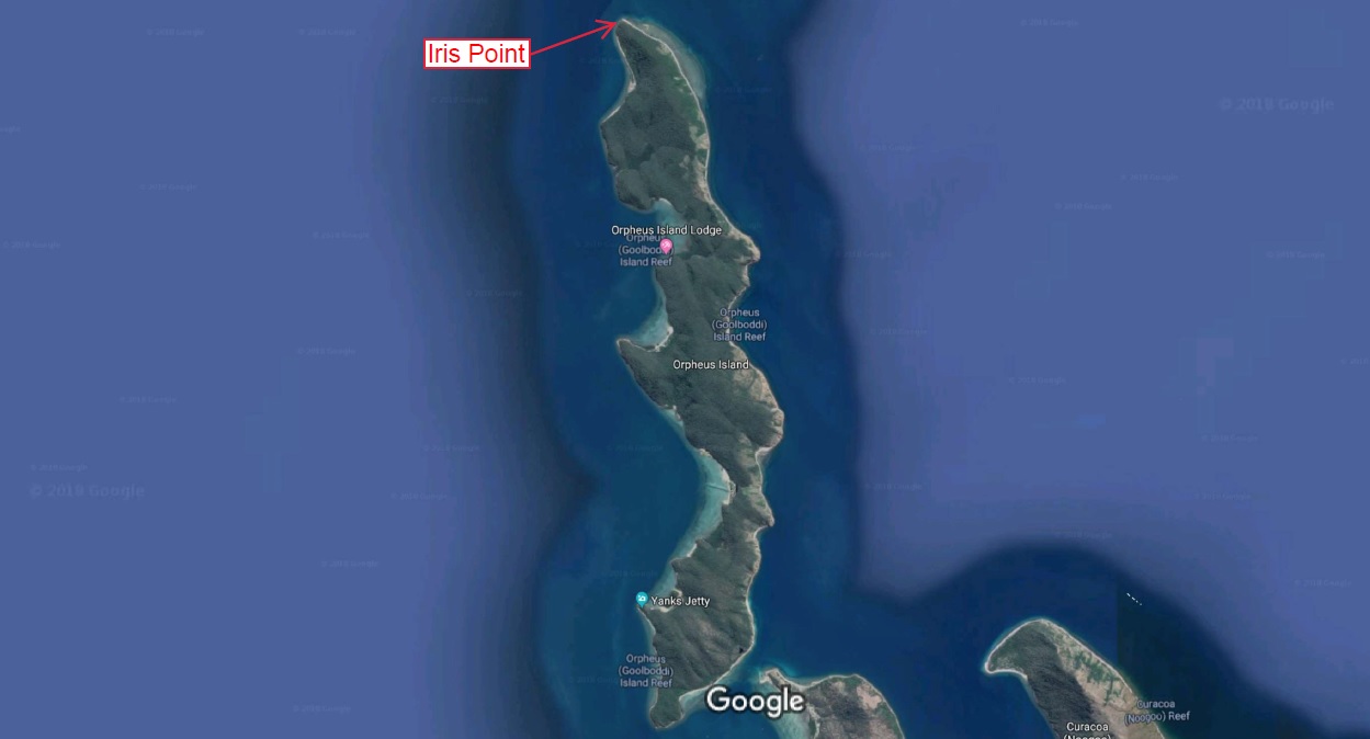 Orpheus Island is a relatively large island (in comparison to Pelorus) at around 11 km long by 1 km wide. Most of its inshore fringing reef is Marine National Park (green zone), except for waters between Hazard Bay and the southern tip of the island which are Conservation Park (yellow zone). Orpheus Island has three National Park campgrounds with a range of basic facilities including composting toilets, tables, and gas barbecues. Permits can be obtained through the QLD Department of Environment and Science website. The island is also home to a large James Cook University marine research facility at the southern end of Pioneer Bay.
Note: During the construction of the following content, we reviewed dozens of dive log book entries for club dives all around Orpheus island. In the truest sense of exploratory diving, many were done based on how the visibility appeared on the day, plus what we thought the structure might look like. Therefore, some dives were pretty ‘unremarkable’ and lasted only minutes, whereas others were enjoyable and kept us coming back. So whilst the following sites by no means represent the fullest extent of potential Orpheus sites, they are sites we felt are easy to describe and to access, and which consistently produce good diving.
Iris Point: This point marks both the northern tip of the island, and the start of the channel’s eastern edge (looking out to sea). The reef wall here extends in places down to 15m in depth, and visibility usually ranges from 6m to 10m. I’ve made some memorable fish finds at this site such as; QLD grouper, grey reef sharks, and leopard sharks. This site also has very suitable terrain for painted crayfish, with ledges and cracks often supporting several crayfish living side by side.
OIRS Point: The research station is located at the southern end of Pioneer Bay, which has a large intertidal zone extending out towards the point to the west of the station. This area is great for snorkelling, but divers here on their initial visits quite often tend to stay out wide of the point in search of deeper water. However, it really is worth persevering in the shallows because you will find a pretty little reef wall, and a surprising amount of fish life close to the point. The area has also been used for giant clam research, so it holds some impressive patches of these animals.
Aim to dive here on a high tide, and you will need good buoyancy control, with your gear streamlined and well-restrained. Also ensure you are sufficiently weighted, especially towards the end of the dive as your cylinder becomes more buoyant.
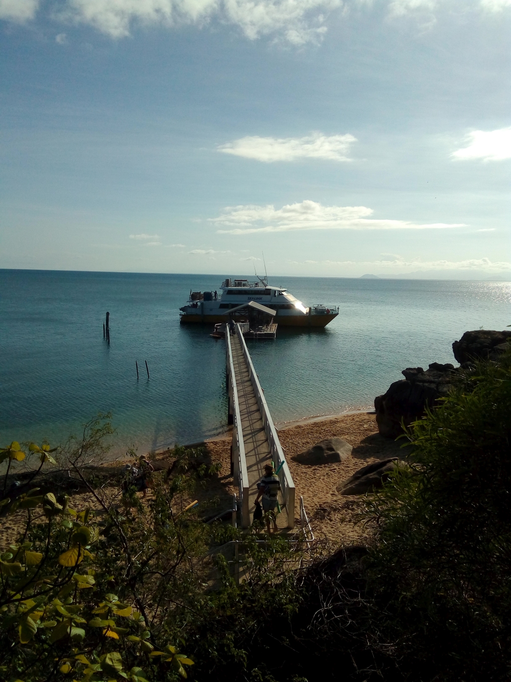 Yanks Jetty: This is the name of the jetty at the northern end of the beach just below Hazard Bay. Its name derives from the use of the area as part of a degaussing station for allied shipping in WWII. It is a popular spot for local day-trippers, island campers, and even Orpheus Island Lodge guests. The location has also been widely promoted through the recent introduction of Sea Link tours for Townsville based day-trip customers.
The mooring section of the jetty is supported by pontoons which allows the structure to move with the tides. The resident fish under this floating section of the jetty are very inquisitive and great fun to snorkel or dive with. Depending on tide, depth under and around the jetty ranges from 4m to 8m. During our last visit, we found large schools of fusilier, jacks, and diamond fish circling around in the shadows under the jetty, but you had to ‘shoo’ the sergeant majors out of the way first. The area surrounding the jetty is also worth exploring, as you can find interesting coral bommies, anemones, and giant clams all within 50m of it.
Note: Depending on how you access this site, you will need to be aware of the no-anchoring areas in the vicinity of the jetty.
Man versus Cyclone on Pelorus Island
This tale is a light-hearted account of an experience we had with bad weather at one of our favourite local destinations. We remained safe throughout the ordeal, but in hindsight we should have heeded the forecast and postponed our trip. Hopefully our misadventure brings a few chuckles.
In January 2010, a dozen intrepid NQUEC members prepared to spend their Australia Day Long Weekend camping, diving, socialising, and relaxing on beautiful Pelorus Island. It’s worth noting here that this trip pre-dates Tropical Cyclone Yasi (February 2011), and whilst I shouldn’t speak for the whole group on the subject of cyclones, my own experience with them up to this point was pretty limited.
For transport to and from the island, NQUEC had chartered a vessel and a skipper from the Orpheus Island Research Station (OIRS). Arrangements were made to launch from Taylors Beach on Saturday morning; although by mid-week, concern was mounting over a low pressure system forming in the Coral Sea. As the weekend approached, the system tracked towards the coast, and strong wind warnings were issued from Cape Melville in the north to St Lawrence in the South. By Friday, OIRS staff reported that they were no longer able to ferry our group, as their guidelines prevent passenger carriage once Bureau of Meteorology forecasts reach 20 knots locally.
This decision was well received by our group and we fully understood and accepted their reasoning; although, a couple of folks quietly floated the idea of going over in a private vessel. We thanked the OIRS staff, and the participants all went their separate ways, except for four members of the original group; who comprised a skipper and three hearty first mates! We hastily sorted our gear, looking for ways to economise and reduce space. Our little party of adventurers departed Townsville at 5am Saturday morning, co-incidentally the same time as when the low pressure system officially intensified into Tropical Cyclone Olga.
We had a slow trip over due to a nasty south-easterly swell, which eased only when we were within a stone’s-throw of the island. After setting up camp and grabbing some lunch, the skipper and I prepared for our first dive. We walked in off the beach along the north-western shore, at a site we refer to simply as ‘Southern Wall’. We worked our way along the base of the wall passing the very impressive six foot black coral tree, and found a coral research project which looked like a stack of bread creates; with each create supporting a different coral type.
By early Saturday afternoon, we’d settled in to our island home and were starting to feel pretty good about coming over. In-fact, as the breeze died down and the afternoon sun shone, we were even making light of our situation with comments like; “oh what terrible weather” and “gee it’s a tough life here!”
For our next dive, we decided to follow the shallow reef wall towards the northern end of the beach. We found a healthy population of juvenile coral trout, plus a few adult trout, and some interesting little tri-coloured nudibranchs.
We finished our diving on Saturday at 3pm, and gathered around a beach camp fire with some finger-food and drinks. That afternoon in the fading light, we noticed two Navy warships moving south close to the coast, and through binoculars it was clear they were not sparing the horses! We wondered why they were steaming away so fast, but only briefly, with conversation centred on planning our next fun-filled day. As we slept, TC Olga further intensified into a Category 2 system and continued tracking towards the coast. Little did we know how much our tropical paradise was about to change……
At 5am the next morning, I woke suddenly as a howling wind began to remove the rain-fly from my tent. Amidst the commotion, I noticed a second sound, one which I had never heard before on Pelorus Island. Through the twilight I could see the cause of this strange sound, as half-meter waves crashed over the intertidal zone. Surf on the beach, on the inside of Pelorus!
Hinchinbrook Island and the mainland were now both completely covered from view, as a huge black curtain of foul weather marched towards us from the north-west. We all felt rather small in comparison to the weather bearing down at us, but our attention quickly turned to the boat, which was being thrown around at anchor just in front of our camp site.
With a lot of determination and effort; our skipper managed to reach the vessel on his inflatable kayak. Whilst he was happy the anchor was holding for the moment, the only way to be certain would be by checking it on the bottom. I quickly changed cylinders and began wading, tripping, and stumbling out to the boat. I descended to the anchor by following the line, and found it hooked precariously around a small rock. Within two meters of the anchor, I spotted a lone circular lump of rock just over a meter in diameter. The base of this lump had an over-hang which I judged might be just the right size to accommodate the flukes of the anchor. I watched the anchor and noticed that each pull from above was separated by a period of slack which lasted about two seconds, long enough I thought to grab it, move it to the lump, and jam it under the over-hang. I timed my move, picked up the anchor and made a rush with it for the rock lump. With the anchor set, I soon realised that this was actually the easy part of the operation, and moving the remaining chain would be quite a different proposition! I was also wary of handling the chain, as I figured the force from the moving vessel would be unforgiving on a mis-placed finger. With a lot of heaving and hoeing, I eventually managed to fully encircle the rock lump with chain, whilst still leaving the nylon line clear of the reef. The skipper then set a stern anchor and after some nervous observation, we both felt satisfied that we were not going to lose our ride home.
With our transport secured we could now focus on our camp site, which was at risk of being pulled to pieces and scattered all around Halifax Bay. When I arrived back at camp, I discovered a river of water flowing through my tent, which I’d left wide open in my haste to check our boat. Bugger!
Our group’s tarpaulin also needed some serious anchoring, as the driving wind had started to lift our pegs, even though we were using two-foot star pickets! We lowered all the poles so the tarp was only just higher than a camp chair, and collected heavy rocks to pile above the pickets. Over the next 48 hours, collecting and placing these rocks became an important pastime, although walking around under the tarp like a half open pocket knife took a toll on our backs!
As it turned out, we were not the only campers on the island this weekend, and as we battled Mother Nature; we met the other group who had also underestimated the forecast. Their group consisted of two young couples, and like us, were also struggling to keep their boat anchored, although they didn’t have the benefit of being able to set their anchors from the bottom with SCUBA gear. At one point that afternoon, we noticed their vessel heading south just off the beach. At first we weren’t sure if it was dragging anchor (because it was moving so quickly that it seemed like it could be under power), but once it passed within centimetres of the rocks; our fears were confirmed, so we raced up to their camp site to bare the bad news.
Our group then witnessed a truly Herculean battle with the elements! By the time their skipper entered the water, his vessel was looking smaller and smaller by the minute as it floated away towards Orpheus Island. We kept track of his progress with binoculars from the beach, and after 15 minutes of frantic swimming; both groups were relieved to see him motoring back to the beach. Evidentially he had packed spare anchors, so we left their group to re-secure their boat and returned to fixing and re-enforcing our own battered little home. We spent the rest of Sunday hunkered down under our tarp as TC Olga made its final approach to the coast, just south of Cairns. During this period, we put any aspirations we had for fine island-dining on hold, and resorted to eating rudimentary meals in subsistence style; straight from the container.
Fortunately for us, the Olga system weakened back to a tropical low upon reaching land, so whilst conditions on the island on Monday morning still weren’t great, things had at-least improved from Sunday. The surf on the beach had abated, and I found it easier to swim out to check our anchors; although this time I had to find each one by feel, as the water in the bay had completely silted out. Our duo of bottom-set anchors were proving successful, so with the worst of the weather seemingly behind us, we were keen to leave our shelter and explore the island. The storm tide had dramatically changed our bay by heaping broken coral along the top of the beach, which was now also littered with broken foliage and flotsam.
With the weather on the mend we decided to delay our departure by a day, although the other group thought it wise to make hay whilst the sun shone, and promptly left that morning. We didn’t get back in the water on Monday because of the poor visibility, but we still enjoyed ourselves now that we could wander around in relative comfort. We spent the afternoon amassing a huge pile of drift wood. That evening, our beach camp fire may very well have been visible from the mainland, as we recounted the trials and tribulations of the previous 48 hours and celebrated the departure of TC Olga, making our eskies significantly lighter in the process!
We awoke to beautiful conditions on Tuesday morning, so we went for a dive to see if we could find the other group’s anchors. We began a search
based on the position of our boat and our memory of their boat in relation to ours. Within minutes we spotted a reef-pick facing south. We then turned 180 degrees and swam about 20 meters where w
e found a sand anchor facing north. In each case, the line had been cut by abrasion with the reef.
With their anchors retrieved, we had enough air remaining for a short lap around the area, and it was good to see a healthy little population of juvenile painted crayfish living in the shallows. At noon, we used the last of our cylinders to complete one final dive towards the northern end of the beach, and by this time the water visibility had improved to about 5 or 6 meters.
After lunch we packed up our trusty little home and loaded the boat for an early afternoon departure. We waved goodbye to the island with a degree of accomplishment, and as we sped back to Dungeness over beautifully flat water; we all wore big smiles and shared an unspoken sense of relief that we had rolled the dice with Mother Nature, and actually gotten away with it!